Know your land before you act. Documents tell you what is recorded; LandAmin helps you understand what actually exists on the ground. Operating across a verified 20 km radius in Deoghar, Jasidih, Madhupur, Mohanpur, and Devipur with authentic Cadastral Survey maps, Brass Gunia triangulation, and SPT Act 1949 legal compliance.
Under Section 20 of the SPT Act 1949, the sale, gift, mortgage, or transfer of agricultural Raiyati land in Santhal Pargana is strictly barred. Only legitimate Basauri (बसौरी) land (homestead/urban plots officially settled for non-agricultural dwelling) is legally transferable through registration. Uninformed buyers frequently face cancellation orders and eviction under Section 42.
Rigorous, evidence-driven field operations conducted with certified instruments, historical maps, and transparent documentation.
Accurate plot length, width, diagonal checking, and exact area calculation in Kattha, Bigha, Dhur, Dismil, and Square Feet matching the Deoghar 6-haath Laggi formula.
Explore Measurement in Deoghar →Establishing undisputed corner boundary points (खूंटा गाड़ना एवं मेड़बंदी) through mathematical triangulation from permanent government Seemana revenue reference stones.
Explore Demarcation in Deoghar →Flagship 16-point physical and record verification before paying advance token money. Comparing on-site physical possession with deed boundaries and government portal records.
Explore Due Diligence Audit →Need a plot in Deoghar? Tell us your budget and preferred locality. We source private options across Jasidih, Devipur (AIIMS), and Kunda (Airport), vetted for SPT Act Section 20 Basauri validity.
Start Plot Sourcing in Deoghar →Empirical division of ancestral land holdings. Drafting equitable Taksim maps ensuring fair road frontage, access rights, and mutual family consensus.
Explore Partition Measurement →Cross-checking 1908 Cadastral Survey maps with modern field coordinates to uncover historical road alignments, canal tracks, and plot shape alterations.
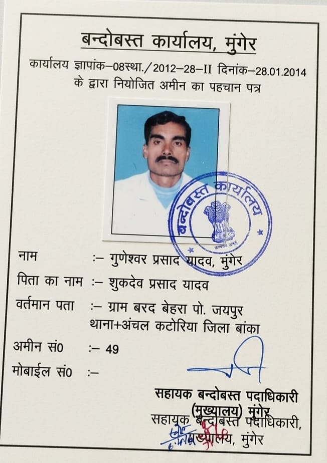
Explore Map & Record Services →Inspect high-resolution Mouza vectors, review Electronic Total Station telemetry, and conduct private video consultations directly with Senior Amin Guneshwar Yadav.
Enter Virtual Studio →We genuinely serve the following sub-divisions and blocks across Deoghar district with prompt field deployment:
Specialized in industrial corridor boundary alignment, Rohini historical Mouza plots, residential colonies, and Basauri status verification near Jasidih Junction.
Explore Jasidih Services →Rapidly transforming area with high commercial land demand. Rigorous roadside setback measurement, government corridor boundary checks, and agricultural title vetting.
Explore Devipur Services →Trikut foothills, highway expansion plots, rural Mouza demarcation, and ancestral family partition measurement along traditional village Chouhaddis.
Explore Mohanpur Services →Municipal holding boundary verification, Pathrol estate ancestral lands, commercial property title checks, and subdivision partition mapping.
Explore Madhupur Services →Large agricultural parcel boundary checks, canal boundary disputes, co-sharer partition surveys, and Jharbhoomi Register-II land record reconciliation.
Explore Sarath & Palojori Services →Castairs Town, Williams Town, Bilahri, Kunda, Bompas Town, and urban residential plots requiring millimeter-accurate boundary and setback verification.
Unlike South Bihar where a 5.5-haath Laggi is prevalent, Deoghar and Santhal Pargana standard revenue calculations predominantly use the 6-Haath Laggi (9 Feet / 108 Inches). Applying the wrong Laggi formula causes major square footage discrepancies during property registration:
आप वेबसाइट के 'Book Site Visit' बटन या आधिकारिक WhatsApp नंबर (+91 99390 54883) पर संपर्क करके बुकिंग कर सकते हैं। देवघर सदर, जसीडीह, मोहनपुर और देवीपुर में 24 से 48 घंटे के भीतर सरकारी प्रमाणित अमीन मौजा के मूल नक्शे व जरीब के साथ स्थल पर उपस्थित होकर नापी पूरी करते हैं।
संथाल परगना काश्तकारी अधिनियम 1949 की धारा 20 के तहत कृषि रैयती जमीन की रजिस्ट्री अवैध व शून्य है। केवल 'बसौरी' (गैर-कृषि) जमीन की ही वैध रजिस्ट्री संभव है। LandAmin की 16-बिंदु जांच खतियान, पंजी-II, दाखिल-खारिज और मौके पर भौतिक कब्जे की पुष्टि कर आपको अवैध सौदे से बचाती है।
किसी भी निजी जमीन की स्वतंत्र नापी मान्य नहीं होती। अमीन हमेशा मौजा नक्शे में दर्ज स्थायी सरकारी सीमाना पत्थर (Seemana / Tihadda / Chohadda) को आधार बिंदु मानकर गणितीय त्रिकोणीयन (Triangulation) विधि से आपके प्लॉट के चारों कोनों का सटीक निर्धारण करते हैं ताकि पड़ोसियों से विवाद न हो।
हाँ। LandAmin द्वारा हर नापी व जांच के बाद 360° जियोटैग्ड फोटोग्राफ, चौहद्दी स्केच, मौजा नक्शा मिलान और सरकारी प्रमाणित अमीन द्वारा हस्ताक्षरित विस्तृत फील्ड ऑडिट रिपोर्ट प्रदान की जाती है, जिसे आप अपने रिकॉर्ड में सुरक्षित रख सकते हैं।
Don't risk advance token money or start construction on disputed boundaries. Speak directly with experienced local Amin for site inspection.