LandAmin replaces verbal claims and paper ambiguities with on-site cadastral measurement and verified revenue intelligence. Whether you are buying, measuring what is yours, or resolving boundary disputes—our veteran field team delivers objective ground clarity.
बिहार और झारखंड में ज़मीनी सच्चाई जानने के लिए सरकारी नक्शा अनुसार सटीक पैमाइश और विधिक जांच।
We do not force you to navigate disconnected technical jargon. All our field and advisory capabilities serve one of these three fundamental purposes:
“Is this land safe to buy? (क्या यह जमीन सुरक्षित है?)”
बयाना देने या रजिस्ट्री से पहले गहन भौतिक व विधिक जांच। कैडस्ट्रल नक्शा मिलान, दाखिल-खारिज व जमाबंदी इतिहास, संताल परगना SPT Act धारा 20 प्रतिबंध और सड़क पहुंच का ऑन-ग्राउंड सत्यापन।
“What is actually mine on the ground? (ज़मीन पर वास्तव में मेरा कितना हिस्सा है?)”
सरकारी अनुभवी बंदोबस्त अमीनों द्वारा पारंपरिक जरीब व इलेक्ट्रॉनिक टोटल स्टेशन (ETS) से नापी। मौजा के ऐतिहासिक सीमना पत्थरों से नक्शा मिलान और 5.5, 6, 6.5 हाथ लग्गी अनुसार प्रामाणिक रकबा गणना।
“Where is the line / How to divide? (सही मेड़ कहाँ है / बंटवारा कैसे करें?)”
मेड़ (Medh) विवादों का तकनीकी समाधान, पैतृक पुश्तैनी बंटवारा (Family Partition), और धारा 163 BNSS (पूर्व 144 CrPC) या DCLR कोर्ट हेतु निष्पक्ष तकनीकी साक्ष्य रिपोर्ट।
Transparent pricing and clear deliverables designed for individual buyers, families, and commercial developers:
Digital Preliminary Risk Assessment
First-time buyers checking a plot online before visiting.
Professional Field Verification
Buyers, families, and landowners making financial transactions.
Premium Transaction & Commercial Due Diligence
Commercial buyers, builders, outstation NRIs, multi-plot investors.
Select any specialized service below to view technical scope, standard turnaround, and schedule an on-site visit:
डिजिटल एवं पारंपरिक भू-सर्वेक्षण
Complete topographic and cadastral surveying using ETS, GPS coordinates, and standard Gunia chain based on official Mouza sheets.
सटीक रकबा एवं परिमाप नापी
Precise dimension measurement in Kattha, Bigha, Dhur, Dismil, and Square Feet calibrated to regional Laggi standards (5.5, 6, 6.5 haath).
स्थायी सीमा खूंटा गाड़ना
Permanent boundary corner pegging triangulated from government Seemana pillars and neighboring reference plots.
दस्तावेज बनाम जमीनी चौहद्दी
Cross-verifying deed boundaries against actual ground possession to detect subtle encroachments or road-width shrinkages.
सटीक भू-मानचित्र व ट्रेसिंग
Scale-accurate CAD plot maps and Mouza sheet tracings for registry, bank loan valuation, and boundary documentation.
360° फोटो व ग्राउंड इंस्पेक्शन
Geotagged photographic inspections for NRI buyers, outstation landowners, and bank mortgage property audits.
केवाला एवं खतियान श्रृंखला जांच
30-year deed chain integrity, Khatiyan copies, and current revenue receipts verification to confirm title cleanliness.
जमाबंदी पंजी-II में नाम जांच
Confirming seller active name in Government Register-II (जमाबंदी पंजी-II), Lagan receipt status, and absence of prior sales.
सरकारी पोर्टल से नकल निकालना
Extracting certified digital copies from Bihar Bhumi, Jharbhoomi, DLRS Survey 2026, and Parimarjan Plus portals.
16-बिंदु सम्पूर्ण भौतिक व विधिक जांच
Flagship 16-point physical and legal pre-purchase audit report with risk scorecard, possession audit, and access path verification.
क्रेता सुरक्षा एवं मूल्यांकन सलाह
Independent buyer guidance, circle rate valuation, checking non-transferable land categories (such as SPT Act 1949).
दस्तावेज व्यवस्थापन व सीमा स्पष्टता
Organizing title papers, clearing boundary ambiguities, and establishing fair market valuation for smooth transaction.
MVR गणना एवं निबंधन सहयोग
Calculating minimum value register (MVR) rates, stamp duty, token booking on e-Nibandhan/NGDRS, and drafting Chouhaddi clauses.
दाखिल खारिज आवेदन व आपत्ति निवारण
Submitting online Dakhil Kharij applications, tracking Shuddhi Patra, resolving Circle Office objections, and DCLR appeals.
न्यायसंगत पारिवारिक तक्सीम
Equitable Taksim map drafting, road frontage parity, and peaceful ancestral division to prevent generational disputes.
प्रपत्र-3(1) वंशावली व स्वघोषणा
Prapatra-3(1) Vanshavali charts for Bihar Special Survey 2026, affidavits, and genealogical land rights proof.
तथ्यात्मक साक्ष्य व सीमा मिलान
Objective empirical measurement evidence to resolve neighbor boundary conflicts and encroachment complaints peacefully.
1-on-1 वरिष्ठ अमीन परामर्श
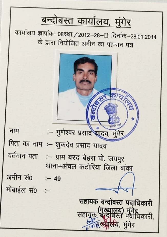
Direct 1-on-1 strategic property consultation with Senior Amin Guneshwar Yadav before taking critical land actions.
Practical answers regarding fees, scheduling, survey equipment, and reports:
अपने मौजा व जमीन का विवरण सीधे सीनियर अमीन गुणेश्वर यादव जी को व्हाट्सएप करें। हम आपकी जरूरत के अनुसार सही सेवा और पारदर्शी समय व लागत बताएंगे।